Commercial Satellite Imaging Market: Current Analysis and Forecast (2022-2028)
Emphasis on Application (Geospatial Data Acquisition, Urban Planning, Disaster Management, Natural Resource Management, Surveillance, Defense & Intelligence, and Others); End-User (Government, Military & Defense, Forestry & Agriculture, Civil Engineering, Transportation, and Others); and Region/Country
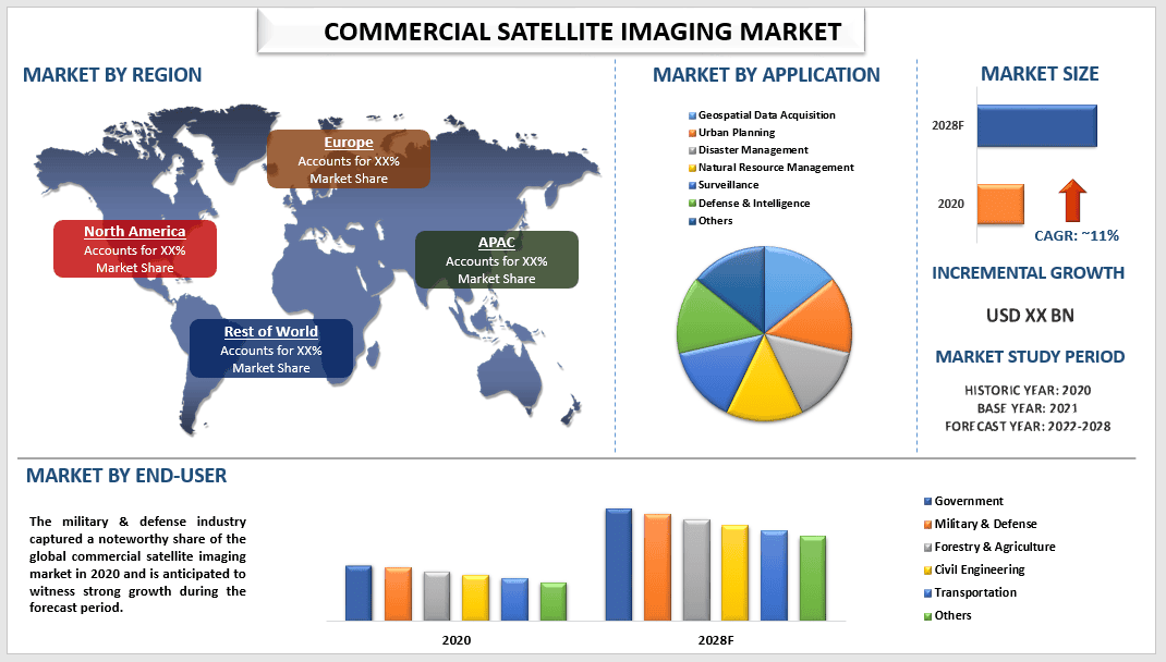
The Global Commercial Satellite Imaging Market is expected to register a CAGR of around 11% over the period of 2022-2028. Commercial satellite imaging is primarily related to the acquisition of images of the Earth by satellites, and the use of these images for a variety of commercial purposes is known as commercial satellite imaging. The main uses of commercial satellites include surveying and mapping, disaster management, energy and resource management, city planning and development, security, and surveillance. Further on, the importance of satellite imagery is heightened by the increasing use of these images in environmental forecasts and the rapid response to emergencies such as defense security events and natural disasters.
The global commercial satellite imaging market is uplifting on account of the increasing usage of satellite imagery for commercial purposes like defense, agriculture, energy, and others and rising concerns about climatic changes, environmental degradation, and disaster monitoring. Moreover, deforestation monitoring followed by the growing security concerns and geopolitical tensions between countries will positively stimulate the industry landscape. Further on, the rising budget of various space agencies is significantly contributing to the growth of this market. For instance, NASA’s budget stood at USD 23.3 Bn in 2021 which rose to USD 24 Bn in 2022. The increasing investment in aerospace industry startups is also driving the growth of the commercial satellite imaging market.
BlackSky Technology Inc., European Space Imaging GmbH, Galileo Inc., Harris Corporation, ImageSat International N.V., Maxar Technologies Inc., Planet Labs PBC, SpaceKnow Inc., Telespazio Spa, and UrtheCast Corp. are some of the key players in the market. Several M&As along with partnerships have been undertaken by these players to facilitate customers with hi-tech and innovative products/technologies.
Insights Presented in the Report
“Amongst application, the defense & intelligence segment held a prominent share in the market in 2020”
On the basis of application, the market is divided into geospatial data acquisition, urban planning, disaster management, natural resource management, surveillance, defense & intelligence, and others. The defense & intelligence segment accounted for a commendable share of the commercial satellite imaging market mainly owing to services provided by satellite imagery to the government and defense agencies for several types of applications such as image fusion, change detection, and land cover classification.
“Amongst end-user, military & defense captured a prominent share in the market in 2020”
Based on end-user, the market is segmented into government, military & defense, forestry & agriculture, civil engineering, transportation, and others. Among these categories, the military & defense segment is expected to showcase a prominent CAGR during the forecast period. Commercial satellite imaging also provides location-based services that help during floods, rescue events, natural calamities, and weather forecasting to develop future programs to simplify situational events.
“North America to witness significant growth during the forecast period”
North America accounted for a significant share of the global commercial satellite imaging market and is expected to grow at a steady growth rate during the forecast period. The growth of the commercial satellite imaging market in the region can be attributed to the increasing use of satellite imaging for security and surveillance purposes and the increasing investment of countries in the development of advanced satellite technology. Further on, the countries in the region are increasing their military budget, which is further impacting the commercial satellite imaging market in the region. For instance, U.S. military spending stood at USD 766.58 Bn in 2020, which increased to USD 801 Bn in 2021.
Reasons to buy this report:
- The study includes market sizing and forecasting analysis validated by authenticated key industry experts.
- The report presents a quick review of overall industry performance at one glance.
- The report covers an in-depth analysis of prominent industry peers with a primary focus on key business financials, product portfolio, expansion strategies, and recent developments.
- Detailed examination of drivers, restraints, key trends, and opportunities prevailing in the industry.
- The study comprehensively covers the market across different segments.
- Deep dive regional level analysis of the industry.
Customization Options:
Global commercial satellite imaging market can further be customized as per the requirement or any other market segment. Besides this, UMI understands that you may have your own business needs, hence feel free to connect with us to get a report that completely suits your requirements.
Table of Content
Research Methodology for the Commercial Satellite Imaging Market Analysis (2022-2028)
Analyzing the historical market, estimating of the current market, and forecasting the future market of the global commercial satellite imaging market were the three major steps undertaken to create and analyze the adoption of commercial satellite imaging in major regions globally. Exhaustive secondary research was conducted to collect the historical market numbers and estimate the current market size. Secondly, to validate these insights, numerous findings and assumptions were taken into consideration. Moreover, exhaustive primary interviews were also conducted, with industry experts across the value chain of the global commercial satellite imaging market. Post assumption and validation of market numbers through primary interviews, we employed a top-down/bottom-up approach to forecasting the complete market size. Thereafter, market breakdown and data triangulation methods were adopted to estimate and analyze the market size of segments and sub-segments of the industry pertains to. Detailed methodology is explained below:
Seek More Details About Research Methodology
Analysis of Historical Market Size
Step 1: In-Depth Study of Secondary Sources:
Detail secondary study was conducted to obtain the historical market size of the commercial satellite imaging market through company internal sources such as annual reports & financial statements, performance presentations, press releases, etc., and external sources including journals, news & articles, government publications, competitor publications, sector reports, third-party database, and other credible publications.
Step 2: Market Segmentation:
After obtaining the historical market size of the commercial satellite imaging market, we conducted a detailed secondary analysis to gather historical market insights and share for different segments & sub-segments for major regions. Major segments included in the report as the application and industry. Further country-level analyses were conducted to evaluate the overall adoption of testing models in that region.
Step 3: Factor Analysis:
After acquiring the historical market size of different segments and sub-segments, we conducted a detailed factor analysis to estimate the current market size of the commercial satellite imaging market. Further, we conducted factor analysis using dependent and independent variables such as various applications and industries of commercial satellite imaging. A thorough analysis was conducted for demand and supply-side scenarios considering top partnerships, mergers and acquisitions, business expansion, and product launches in the commercial satellite imaging market sector across the globe.
Current Market Size Estimate & Forecast
Current Market Sizing: Based on actionable insights from the above 3 steps, we arrived at the current market size, key players in the global commercial satellite imaging market, and market shares of the segments. All the required percentage shares split, and market breakdowns were determined using the above-mentioned secondary approach and were verified through primary interviews.
Estimation & Forecasting: For market estimation and forecast, weights were assigned to different factors including drivers & trends, restraints, and opportunities available for the stakeholders. After analyzing these factors, relevant forecasting techniques i.e., the top-down/bottom-up approach were applied to arrive at the market forecast for 2028 for different segments and sub-segments across the major markets globally. The research methodology adopted to estimate the market size encompasses:
- The industry’s market size, in terms of revenue (USD) and the adoption rate of the commercial satellite imaging market across the major markets domestically
- All percentage shares, splits, and breakdowns of market segments and sub-segments
- Key players in the global commercial satellite imaging market in terms of solutions offered. Also, the growth strategies adopted by these players to compete in the fast-growing market
Market Size and Share Validation
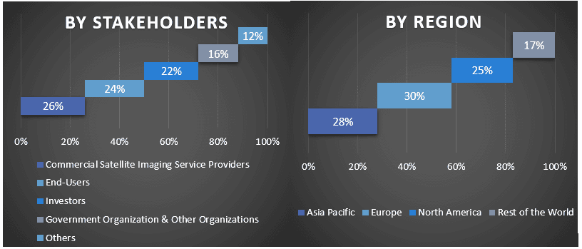
Primary Research: In-depth interviews were conducted with the Key Opinion Leaders (KOLs) including Top Level Executives (CXO/VPs, Sales Head, Marketing Head, Operational Head, and Regional Head, Country Head, etc.) across major regions. Primary research findings were then summarized, and statistical analysis was performed to prove the stated hypothesis. Inputs from primary research were consolidated with secondary findings, hence turning information into actionable insights.
Split of Primary Participants in Different Regions
Market Engineering
Data triangulation technique was employed to complete the overall market estimation and to arrive at precise statistical numbers for each segment and sub-segment of the global commercial satellite imaging market. Data was split into several segments & sub-segments post studying various parameters and trends in the areas of the application and industry in the global commercial satellite imaging market.
The main objective of the Global Commercial Satellite Imaging Market Study
The current & future market trends of the global commercial satellite imaging market were pinpointed in the study. Investors can gain strategic insights to base their discretion for investments from the qualitative and quantitative analysis performed in the study. Current and future market trends were determined the overall attractiveness of the market at a regional level, providing a platform for the industrial participant to exploit the untapped market to benefit as a first-mover advantage. Other quantitative goals of the studies include:
- Analyze the current and forecast market size of the commercial satellite imaging market in terms of value (USD). Also, analyze the current and forecast market size of different segments and sub-segments
- Segments in the study include areas of application and industry
- Define and analysis of the regulatory framework for the commercial satellite imaging market industry
- Analyze the value chain involved with the presence of various intermediaries, along with analyzing customer and competitor behaviors of the industry
- Analyze the current and forecast market size of the commercial satellite imaging market for the major region
- Major countries of regions studied in the report include Asia Pacific, Europe, North America, and Rest of the World
- Company profiles of the commercial satellite imaging market and the growth strategies adopted by the market players to sustain in the fast-growing market
- Deep dive regional level analysis of the industry
<section class=”price-breakup”>
<div class=”img-cl”><img src=”https://univdatos.com/wp-content/uploads/2021/05/UDS-LOGO.png” /></div>
<h4 class=”shares-heading”>You can also purchase parts of this report. Do you want to check out a section wise
price list?</h4>
<div class=”btn-cls”><a class=”download-sample pum-trigger” style=”cursor: pointer;” href=”/contact-us”> Get in touch with team</a></div>
</section>
Related Reports
Customers who bought this item also bought


India IT and BPO Services Market: Current Analysis and Forecast (2026-2034)
Emphasis on Service Type (IT Services, BPO Services, Engineering & R&D Services); Outsourcing Type (Onshore, Offshore, Nearshore); Organization Size (Large Enterprises, SMEs); End-User Industry (BFSI, IT & Telecom, Healthcare, Retail & E-commerce, Manufacturing, Others); and Region/States
Gi-Fi Technology Market: Current Analysis and Forecast (2025-2033)
Emphasis on Product Type (Display Devices and Network Infrastructure Devices); Technology (System on chip and Integrated Circuit Chip); Application (Consumer Electronics, Commercial, and Networking); and Region/Country

DNA Data Storage Market: Current Analysis and Forecast (2026-2034)
Emphasis on Type (Cloud and On-Premises); Technology (Sequence-based DNA Data Storage and Structure-based DNA Data Storage); End-User (Government, Healthcare & Biotechnology, Media & Telecommunication, and Others); and Region/Country
Cloud Service Brokerage Market: Current Analysis and Forecast (2026-2034)
Emphasis on Service Type (Integration and Support, Automation and Orchestration, Billing and Provisioning, Migration and Customization, Security and Compliance, and Others); Platform (Internal Brokerage Enablement and External Brokerage Enablement); Deployment (Private, Public, and Hybrid); Enterprise Size (Large Enterprises, and Small & Medium-Sized Enterprises); End-Use (IT & Telecom, BFSI, Government & Public Sector, Healthcare, Consumer Goods & Retail, Manufacturing, Energy & Utilities, and Others); and Region/Country